


Introduction
Machine Control GNSS Integration with 3D Modeling Software is transforming the way modern construction and earthmoving projects are planned and executed. By combining satellite-based positioning with detailed digital terrain models, contractors can achieve higher accuracy, faster workflows, and reduced operational errors on-site.
In today’s competitive construction environment, machine control gnss Integration with 3D Modeling Software is no longer a luxury—it is becoming a standard requirement for companies aiming to improve productivity and precision.
What is Machine Control GNSS Integration with 3D Modeling Software?
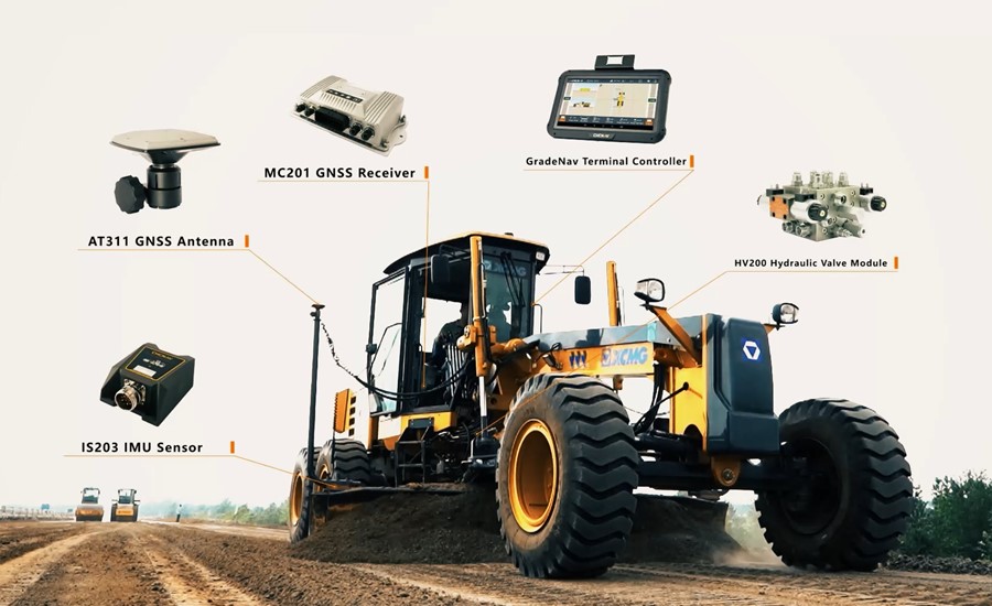
At its core, Machine Control GNSS Integration with 3D Modeling Software refers to the connection between GNSS-equipped machinery (such as excavators, dozers, and graders) and advanced 3D design platforms.
3D modeling software creates a digital representation of the project site, including:
- Terrain elevations
- Design surfaces
- Cut-and-fill requirements
- Infrastructure layouts
This data is then transmitted to machine control systems using GNSS (Global Navigation Satellite Systems), allowing operators to work directly from the digital design in real time.
How the Integration Works on Construction Sites
The workflow of Machine Control GNSS Integration with 3D Modeling Software typically follows these steps:
1. Digital Design Creation
Engineers create a detailed 3D model of the construction site using specialized CAD or BIM software.
2. Data Conversion
The design is converted into machine-readable formats compatible with GNSS control systems.
3. GNSS Positioning
Machines equipped with GNSS receivers determine their exact location on the job site using satellite signals.
4. Real-Time Guidance
Operators receive live feedback showing blade position, depth, slope, and alignment based on the 3D model.
This seamless data flow ensures that Machine Control GNSS Integration with 3D Modeling Software delivers precise execution without constant manual surveying.
Key Benefits of GNSS and 3D Model Integration
Improved Accuracy
One of the biggest advantages is centimeter-level accuracy in grading and excavation tasks.
Reduced Rework
Since machines follow a pre-designed model, costly errors and rework are significantly minimized.
Faster Project Completion
With real-time guidance, operators can complete tasks more efficiently without waiting for survey updates.
Better Resource Management
Fuel, labor, and material usage are optimized through more precise operations.
Overall, Machine Control GNSS Integration with 3D Modeling Software helps construction teams work smarter, not harder.
Applications in Modern Construction
This technology is widely used across multiple industries:
Road Construction
Ensures precise grading and smooth surface creation for highways and urban roads.
Mining Operations
Helps in accurate excavation and material handling in large-scale mining sites.
Land Development
Supports site preparation for residential and commercial projects.
Agriculture and Earthworks
Enhances land leveling and irrigation planning.
In all these fields, Machine Control GNSS Integration with 3D Modeling Software plays a critical role in improving operational efficiency.
Challenges in Implementation
Despite its advantages, companies may face some challenges:
- High initial investment costs
- Training requirements for operators
- Data compatibility issues between systems
- Dependence on satellite signal quality
However, with proper planning and training, these challenges can be effectively managed.
Future of GNSS and 3D Modeling in Construction
The future of Machine Control GNSS Integration with 3D Modeling Software looks highly promising. With advancements in AI, automation, and cloud-based collaboration, construction sites are moving toward fully digital and semi-autonomous operations.
We can expect:
- More autonomous machine control systems
- Real-time cloud-based 3D model updates
- Enhanced accuracy through multi-satellite GNSS networks
- Greater integration with BIM and digital twin technologies
Conclusion
In conclusion, Machine Control GNSS Integration with 3D Modeling Software is revolutionizing the construction industry by bridging the gap between digital design and real-world execution. It enhances accuracy, improves efficiency, and reduces operational costs across a wide range of applications.
